
HuntStand vs OnX Hunt: Which is better for you?
The battle is HuntStand vs OnX Hunt. Both are developed as hunting and mapping apps, designed to tell you the weather, wind direction, GPS location, and topographic and satellite photos. These apps are invaluable for scouting, navigation, and hunting.
But not all apps are the same. Many have annoying pop-up ads. Some are slow to load. Or simply not designed by hunters.
Onx vs Hunstand: OnX is famous for its better single-state price, web, and app combo, and simplicity and reliability whereas HuntStand has an outdated and cumbersome User Interface
HuntStand vs OnX Hunt: Comparison
For this comparison of HuntStand vs OnX hunt, we will focus on the following areas: Pricing, Supported platforms and installation, Mapping views, Offline Maps, Advanced mapping, Property boundaries and ownership, Wind and weather information, Supplemental information, Stand reservation system and Trail camera management.
Pricing
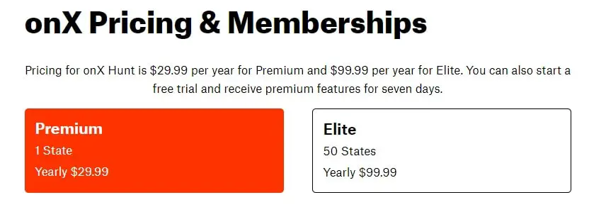
Let’s begin with the OnX hunt. The OnX hunt offers two membership programs namely Premium and Elite. The main difference between the two is that you get access to land data of only ONE state with premium membership priced at $29.99 per year. However, the Elite members of OnX hunt can view land data of 50 states by paying $99.99 per year.
Recommended: ONX CHIP VS APP: WHICH IS BEST FOR YOU?
On the other hand, the pricing of HuntStand is very simple. You pay $29.99 per year to access all the features, covering all the states.
You can also use a free version of both apps with limited functionalities.
Supported platforms and installation
The OnX hunt and HuntStand can be installed on both the iPhone and the android mobile phone platforms.
You simply download the app from the androids app store or google play and set up an account. using your smartphone.
Installation is easy, install just like any other iPhone or android app.
Mapping views
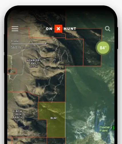
OnX vs Hunstand: OnX Hunt provides 3 mapping views compared to 7 mapping views offered by Hunstand.
The mapping views on OnX Hunt include satellite images, topographic maps, or a hybrid of both. You can choose from satellite photos, vivid satellite photos, topo maps, public land maps, street views, etc on HuntStand.
Offline Maps
Both apps allow you to download maps. This is very important to understand because a lot of times you will not have a signal but your GPS will still work. So if you download maps, the app will work perfectly even if you’re 15 miles from the signal.
Advanced mapping
Advanced mapping features are available on both apps. Some of these features are as follows
- Measure the distance between two points.
- Measure an area
- Add waypoints and location markers
- Draw lines and shapes on the map
Property boundaries and ownership
Property boundaries and ownership information are absolutely critical for every hunter. Perhaps the most impressive feature of these apps. As a hunter, you should be aware of the places you can and cannot hunt.
Onx vs Hunstand: As stated earlier, OnX Hunt offers premium membership at $29.99. With this, you get access to public and private land boundaries with owner detail of only ONE state. Comparatively, you pay $29.99 per year on Hunstand to access unlimited nationwide property data.
Now, you should understand that this data is only as good as the government data that is read. So if the government data is bad, the app is going to translate that data and will not be accurate.
In addition to private property, you can also view public lands such as BLM, state and federal properties, parks, and other locations.
Wind and weather information
This is a great feature for all hunters but particularly for whitetail hunters.
Both apps claim to provide accurate weather information such as temperature, wind direction, Barometric pressure, and moon phases. In addition to that, you also find detailed information about Radar, Precipitation, Snow accumulation, Fires, and Drought Monitor on both apps.
So when comparing HuntStand vs OnX, there is not much difference between the weather information provided by both apps.

Supplemental information
Supplemental information is the supporting information provided to help hunters.
Before we compare this information on both apps, let’s check what is being offered by them.
Here is the list of supplemental information provided by Hunstand.
- Timber thinning / clear cuts
- Fires and burns
- Flooding
- Agricultural activity
- Snow and ice cover
- Detailed Public Hunting Lands
- General Public Lands & Allowable Uses
- TerraPulse Tree Cover
- Natural Atlas
- MapBox Color Corrected Satellite
In OnX hunt, the supplement information is available by state and includes the following:
- CWD information is provided by the quality deer management association,
- big game record distribution is provided by Boone and Crockett.
- Turkey records provided by the national wild turkey federation
- Roadless areas.
- Timber cuts.
- Wildfire history.
- Current wildfires.
- Section Information
- Wilderness areas.
- Recreational areas.
- Trails, Trail slopes, Trail mileages.
- Forest visitor maps.
- Motor vehicle roads and trails.
- Game management units.
- Walk in hunting areas.
- Nautical charts.
- River flood stages.
OnX vs Hunstand: It is clear from the above list that OnX provides much more additional information to its user compared to Hunstand. But there are other features available in Hunstand that are worth noticing. First is the stand reservation system and the second is trail camera management.
Stand reservation system
Now, this is a great feature of the handstand. With the stand reservation system from Hunstand, you can easily manage stands in a hunting area.
Plan your hunting in advance and book the stand for a specific time depending on your schedule. The system is not limited to reservations, you can also view the availability of all stands to organize your hunt. Additionally, you can also get details about the current occupant of any stand
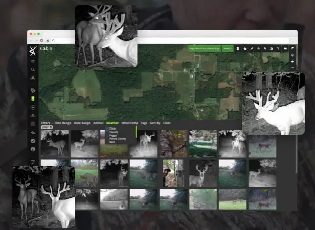
Trail camera management
This is a must-feature for users of trail cameras to manage all their trail cameras. This is considered to be one of the best trail camera management systems with 40GB of storage. You use this storage to save photos.
The AI species recognition system automatically identifies the animal and adds tags to the photos. Also, the trail cameras management system is programmed to add weather and solunar data to all the photos. With this information, you know at what time and condition the photos were taken. You can also keep an eye on trail camera activity by generating heat map
In conclusion, having access to all this information in your back pocket while hunting is hard to imagine but it’s real. And it’s available now with just a simple download and it’s also pretty reasonably priced.
HuntStand vs OnX: Conclusion
The choice to use HuntStand vs OnX is entirely down to personal preference.
OnX vs Hunstand: Huntstand is cheaper than OnX as HuntStand provides nationwide land data at $29.99 per year. But OnX is known to be the more user-friendly and reliable of the two.


![Is the Mathews Phase 4 Worth It? [Honest Review]](https://outdoorsportshub.com/wp-content/uploads/2023/08/Is-the-Mathews-Phase-4-Worth-It-768x432.jpg)
2 years ago onX was great for public/private land ownership and for tracking. Very simple and accurate. However the more it is updated the less reliable and ease of usage has suffered. Has trouble loading hi res satellite image